La Niñas are known to increase tropical activity in the Caribbean, Gulf of Mexico and Atlantic Ocean, but there is typically a lag after entering the ENSO state and seeing the associated climate impacts. Historical data shows that the probability of hurricane impacts are higher during La Niña years.
The current El Nino just reached ‘Super’ El Nino status – for only the 6th time since 1950. But forecasts now show El Nino is about to quickly fizzle out, and likely replaced by La Nina by the summer.
There are less than 120 days before the arrival of the 2024 hurricane season, but for Mother Nature, the processes that lead to tropical weather season begin well before it’s annual start on June 1, and these signals can provide clues as to how busy the season will be.
Forecasters pay close attention to trade winds and water temperature anomalies to determine the status of the El Niño-Southern Oscillation index, or what is commonly referred to as the ENSO.
Historically, La Niñas have produced busy tropical seasons, while the opposite is known to be true during El Niños – when conditions are typically hostile for cyclones in the Atlantic basin.
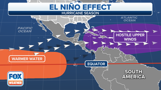
In La Niña patterns, water temperatures in the Atlantic, Caribbean and Gulf of Mexico are usually warmer than average and upper-level winds, which tend to tear systems apart, are less hostile.
During El Niños, forecasters say there is usually much more wind shear around and water temperatures tend not to be as warm in the Atlantic basin.

Significantly warmer water in the key equatorial belt typically correlates with limited hurricane development.
(Image: FOX Weather)
Current state of ENSO
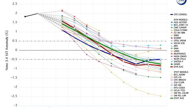
The current El Niño pattern continues to weaken, and climate models anticipate the world will enter a neutral status over the summer.
A march out of an El Niño into a neutral status would require the continued cooling of water temperatures in the central and eastern Pacific.
Once water temperature anomalies reach 0.5 °C or colder, the El Niño will be considered over, and the world will officially be in neutral status. A neutral ENSO runs from 0.5 °C to -0.5 °C and La Niñas are christened once levels reach -0.5 °C or greater.
Agencies such as NOAA and other experts annually warn of a Spring Predictability Barrier, especially during large-scale changes, that can lead to less than accurate model outputs.

Climate model outputs
(Chart: NOAA’s Climate Program Office and Columbia University / FOX Weather)
“If you want to know whether it is going to rain, you are usually better off using a prediction the day before than you are a week out. The same is true in seasonal climate outlooks. However, during the spring, even making an ENSO forecast for the coming summer is pretty difficult,” authors of a NOAA climate blog stated.
Due to the slow nature of change and climate forecast models showing neutral conditions through much of the summer and fall, the 2024 hurricane season will already be well underway by the time atmospheric winds, temperatures and instability levels reach what are considered to be normal for the state.
What the neutral status means for the 2024 season
An average Atlantic basin hurricane season produces 14 named storms, of which seven go on to become hurricanes and three normally reach major hurricane status with winds of at least 115 mph.
Seven of the last eight years have all finished with above-normal activity, including 2018 and 2023, when El Niño patterns were in control in the Pacific.
The 2024 season could be in a similar state to seasons such as 2016, 2010, 2003, 1998 and 1995, when significant El Niño events were on the decline ahead of the next La Niña stage.
These seasons experienced an average of 17 tropical cyclones, nine hurricanes and four majors, which is busier when compared to average.
A busy year does not correlate to high U.S. landfall impacts, but with more cyclone chances comes the possibility that more people could find themselves in a cone of concern.
Last year’s hurricane season was the least impactful for the U.S. in nearly a decade, so only a small uptick in activity can increase the threat level.
Features that forecasters will keep an eye on include the Saharan dust layer and water temperatures, which could dictate early-season activity.
Key outlooks for the 2024 hurricane season will begin to be released in April and May ahead of the season’s June 1 start.

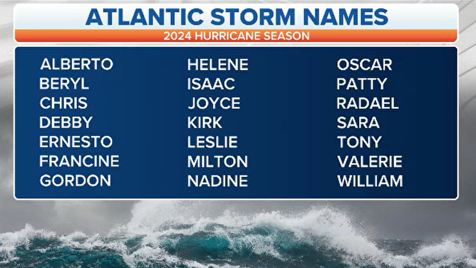
Hurricane season 2024 Atlantic basin tropical cyclone names
(Image: FOX Weather)
Source: Fox Weather, 2024 (https://www.foxweather.com/weather-news/2024-hurricane-season-preview)
